The following system of tables helps you to create your own fantasy world for roleplaying purposes. If you’re just tinkering around, or if you’re a traditional GM putting together aworld, go ahead and roll things up as you see fit.
But if you’re using this system as written, for collaborative play, then you should remember the fundamental principle: the details of the world are only determined when the characters get reliable information about them, whether by asking someone, doing research, or simply going there. Not before!
This means you should begin by determining just those basic things about the world that the characters already know. The rest of the game world’s important details –i.e. the vast majority of the world – will be created during the campaign. If you’re using the full system, then this means that most of the world will be created while rolling up Adventures and completing Journeys. If you want some thoughts (and even hard rules) about the kind of things that the PCs might or might not know about the world, head here.
EDIT: if you want to see an example of how this world creation system works, then you might want to check out my Example of World Creation series, in which I walk you through the whole process!
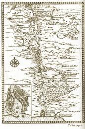 The World Map
Making a map of a fantasy world is an excellent use of your time.
You’ll need:
- 3d6 (or an online die roller).
- A huge sheet of paper.
- An insatiable appetite for fun.
Map Scale
This system uses “a day’s travel” as a unit of measurement.
If you don’t have a truly huge sheet of paper, and you’re just using an A4 sheet, then things are going to be a bit tight. If you’re using just an A4 sheet, then each day’s travel should measure about 1cm or so (a bit less than half an inch, for you imperial folks).
But really, world building works best on a vast sheet of paper – a huge sheet of “butcher’s” or “construction” paper would be ideal. A whiteboard, blackboard, or dry-erase board would be great, too. In the best case scenario, you’ll have room to make each day’s travel measure an inch or more. That will make for a huge map, leaving you plenty of room to fill in details as you go.
Once you’ve gathered your map-making materials, it’s time to start making your first Region!
Creating the World, Region by Region
The world map is built up gradually, one Region at a time. Eventually many of these Regions will be joined together into unified Kingdoms, Realms, Principalities, and so on, each consisting of multiple adjacent Regions (though a few Regions will probably remain singular and independent even then). So be aware of that.
Each Region has seven characteristics, as follows:
- Size
- Climate and Terrain Type
- Level of Civilization
- Settlements
- Population Type
- Theme
- Monster Ecology (including Primary, Secondary, and Tertiary monster types.
To create Regions you determine each of their characteristics in order, and adding them to the World Map as you go along. You should probably put the first Region in the center of the map, leaving plenty of room around it, so the map can be expanded in all directions.
Without further ado, on to the tables!
1 – Size
Roll 3d6. (Need a die roller?) Triple all distances when at sea.
| Size | Time to cross |
|
| 3-8 | Tiny | A day or so. |
| 9-12 | Small | 1d6x2 days. (die roller) |
| 13-15 | Large | 2d6x2 days. (die roller) |
| 16-18 | Vast | 5d6x2 days. (die roller) |
The “Time to Cross” here gives you a sense of how large the Region ought to be: this is roughly how long it would take to travel along the Region’s longest axis.
Most Regions should be vaguely blob-shaped, if that makes sense – but don’t draw it on the map just yet, because its shape will depend on the Terrain Type – some Regions are long, thin, and snaky, like Rivers and Beaches.
2 – Climate and Terrain Type
All regions have a Climate and a Terrain Type.
Climate (e.g. “Temperate”, “Alpine”) is the broader category: it changes only slowly as you travel from place to place. Terrain Types (e.g “Plains”, “Forest”) change more frequently. Each Terrain Type fits into one or more Climates.
- If you’re creating the first Region, roll here.
- If you’re heading out to sea from a Beach Region, don’t roll – just declare the next Region an Ocean!
- If you’re extending an Ocean, roll here.
- If you’re extending a Polar Climate, roll here.
- If you’re extending a Beach, don’t roll! Coastlines don’t just end, so any Region that extends an existing coastline is automatically also a Beach region. “Beach” Regions should be drawn as long and narrow, like real coastlines.
- If you’re extending a River, roll here. “River” Regions should be drawn as long, narrow, and meandering, like real river valleys.
For all other Regions, roll on the following table:
What is the New Region’s Climate and Terrain Type?
Roll 3d6. (Need a die roller?)
If the Region you’re creating is Tiny, you can either add or subtract 2 – your choice!
Then compare the Region to one of its immediate neighbors. Compared to the Neighboring Region, this Region has….
| 3-9 | … the same Climate, but a different Terrain Type. Roll for a new Terrain Type, on the table below – but if the result is the same, re-roll it. |
| 10-13 | … the same Climate and Terrain Type. Now it’s time to move on to step 3 – determining the Region’s Level of Civilization. Scroll down! |
| 14-18 | …a totally different Climate and Terrain Type. First determine the new Climate on the table below, and then determine the new Terrain Type on the table beneath it. If either result is the same as the current type, re-roll it. |
To Determine a New Climate Type
If the Region you’re working on has a new Climate, then determine what it is by rolling 1d. (Need a die roller?)
If you’re in the North of the map, and you’re heading North, shift the Climate to: (1) temperate (2) coastal (3-4) alpine (5-6) polar.
If you’re in the central latitudes, shift the Climate to: (1-2) temperate (3-4) coastal (5-6) alpine.
If you’re in the South of the map, and you’re heading South, shift the Climate to: (1) temperate (2) coastal (3-4) humid (5-6) arid.
Of course, this all assumes you’re mapping a reasonably standard fantasy continent in the Northern Hemisphere. If you want your continent to be in the Southern Hemisphere, just reverse the values for North and South, above.
To Determine a New Terrain Type
If the Region you’re working on has a new terrain type, then determine what it is by rolling 1d and referring to the current Climate. (Need a die roller?)
| Temperate | Alpine | Polar | Coastal | Humid | Arid | |
| 1 | Plains | Mountains | Arctic | Beach | Jungle | Desert |
| 2 | Plains | Mountains | Arctic | Beach | Jungle | Desert |
| 3 | Hills | River | Arctic | Forest | Swamp | Plains |
| 4 | Forest | Lake | Arctic | Hills | Swamp | Hills |
| 5 | River | Forest | Mountains | River | River | Mountains |
| 6 | Lake | Arctic | Mountains | Swamp | Lake | River |
3 – Level of Civilization
Regions are either Civilized, Semi-Civilized, Wilderness, or Monstrous. These four levels are in a hierarchy: Civilized is the highest, and Monstrous is the lowest. For more in-depth description of these four levels, head here.
To determine the starting Region’s Level of Civilization, roll 3d6. (Need a die roller?)
Modifiers: Add 2 if the Terrain is Forest or Mountain. Add 4 if the Terrain is Ocean, Swamp, Arctic, Desert, or Jungle. If the Region you’re creating is Tiny, you can also either add or subtract 2 – your choice!
| 3-11 | Civilized |
| 12-13 | Semi-Civilized |
| 14-17 | Wilderness |
| 18+ | Monstrous |
To determine the Level of Civilization of any other Region, roll on the following table:
How Civilized is this Region?
| Roll 3d6. (Need a die roller?)
Modifiers: Add 2 if the Terrain is Forest, Mountains, Ocean, Swamp, Arctic, Desert, or Jungle. If the Region you’re creating is Tiny, you can also either add or subtract 2 – your choice! Then compare the Region to one of its immediate neighbors. Decide which neighboring Region to compare after rolling, on the basis of which choice seems like it makes the better map. Compared to the Neighboring Region, this Region is…
|
4 – Settlements
Most Regions contain settlements of one kind or another. This system makes provision for determining the number of Cities, Towns, and Villages in the Region, as well as Castles – by which is meant any large building built primarily as a fortification – and those Lone Taverns In The Middle Of Nowhere that fantasy authors are so fond of.
For more information on all of these – and for how to create them in detail, when the time comes to do so – see the pages on Towns. (They’re not yet up, sadly! Give me time!)
Cities and Towns
The number of Cities and Towns in a Region is determined when the Region is first created – which is to say, whenever the PCs gain access to information about the Region at that level of detail. If you’re creating a new Region, roll on the table at the bottom of this page, and then place the indicated number of Cities and Towns on the map, wherever seems best.
Castles, Villages, and Lone Taverns
These are not determined in advance at all – instead, it’s assumed that they dot the landscape fairly regularly in civilized Regions, and turn up from time to time in less civilized Regions, too. Any time the PCs want to know if there’s, say, a village nearby, they can either ask a local to point them in the direction of the nearest village, or start looking around by themselves.
At that point, roll 3d6. If you roll under the listed target number, you’re in luck – there’s one within an afternoon’s travel. If you fail, the PCs can spend another day traveling to a different place within the region and then try again – unless you’re in a “Tiny” region, in which case a day’s travel will bring you to a different region; you can try your luck there, instead.
A Note on Monstrous Settlements
You’ll notice that Monstrous Regions do contain settlements of various sizes – but remember that they’re monstrous! Unless your PCs have a good disguise, or some way to make nice with the monsters, you’re usually better off avoiding them.
A Note on Settlements in Oceans
If you’re creating an Ocean Region, feel free to declare that there are no settlements, if you so desire. On the other hand, you could easily include them: cities and towns could easily be housed on small islands or archipelagos – or, this being fantasy, they may even be underwater…
How Many Settlements Are In This Region?
|
||||||||||||||||||||||||||||||||||||||||||||||||||||||||||||||||||||||||||||||||||||||||||||||||||||||||||||||||||||||||||||
NOW FOR THE FUN!
If you’ve only just made the first Region, head back up to step 1 and create some neighboring Regions, until you’ve got a fairly sizeable map.
Starting to Pull Things Together
Once you’ve made an interesting and fairly sizeable map, with many Regions, and a bit of information about all of them, it’s time to start to work out what it all means. If you’ve been imagining a little as you’ve gone along – and I hope you have! – then you’ll probably already have some ideas about where the borders of specific Realms and Kingdoms might lie,; who might live in each area; which areas are safe, and which are dangerous – and so on.
Now might be the time to put some of that information on the map by joining up some the Regions into Realms, Kingdoms, Principalities, and so forth. You can also leave this process until a bit later, if you like – just do it whenever it seems most natural.
Whenever you do it, it will mean declaring that this Civilized Region, this Civilized Region, and this Semi-Civilized Region together make up a single Realm; whereas that Civilized Region is obviously ruled by someone else. Declare that these two Wilderness Regions are untamed and claimed by no-one, whereas that Wilderness Region is claimed by the nearby kingdom – and so on.
Realms can comprise as many or as few Regions as you like – do what feels best! But be prepared to make adjustments, later.
This process should be a lot of fun! At the end of it, you should have a map that is beginning to look a bit like a serous fantasy map, with Realms, Kingdoms, and isolated Regions, all of various sizes.
Now, back to the tables…
5 -Population Type
You can determine a Population Type for each individual Region, or for whole Realms – your choice! An of course, you can just declare it so, if you like: if you have strong feelings about it already, you can just declare this the Kingdom of the Elves, this the Realm of the Knights of Neverguard, or whatever. But these tables are here if you want them.
Note that a Realm or Region’s Population Type is an indication of the dominant type of civilized creature in the Region. In a Civilized area, this tells you a lot – it gives you a sense of the character of the whole Realm, Kingdom or similar. In a Wilderness, it tells you quite little, since there are so few Civilized people around. Still, it helps you determine what kind of person might turn up, if anyone does.
To determine a Realm or Region’s dominant population type, refer to the following table.
Population Types by Terrain Type and Level of Civilization
Roll 1d, 1d and refer to the appropriate Terrain Type and Level of Civilization. (Need a die roller?)
| Civilized/Semi-Civilized | Semi-Civilized/Wilderness | Monstrous | ||||||||||||||||||||||||||||||||||||||||||||||||||||||||||||||||||||
| Plains |
|
|
|
|||||||||||||||||||||||||||||||||||||||||||||||||||||||||||||||||||
| Hills |
|
|
|
|||||||||||||||||||||||||||||||||||||||||||||||||||||||||||||||||||
| River |
|
|
|
|||||||||||||||||||||||||||||||||||||||||||||||||||||||||||||||||||
| Lake |
|
|
|
|||||||||||||||||||||||||||||||||||||||||||||||||||||||||||||||||||
| Beach |
|
|
|
|||||||||||||||||||||||||||||||||||||||||||||||||||||||||||||||||||
| Forest |
|
|
|
|||||||||||||||||||||||||||||||||||||||||||||||||||||||||||||||||||
| Mountains |
|
|
|
|||||||||||||||||||||||||||||||||||||||||||||||||||||||||||||||||||||||||||||
| Ocean |
|
|
|
|||||||||||||||||||||||||||||||||||||||||||||||||||||||||||||||||||||||||||||
| Swamp |
|
|
|
|||||||||||||||||||||||||||||||||||||||||||||||||||||||||||||||||||||||||||||
| Arctic |
|
|
|
|||||||||||||||||||||||||||||||||||||||||||||||||||||||||||||||||||||||||||||
| Desert |
|
|
|
|||||||||||||||||||||||||||||||||||||||||||||||||||||||||||||||||||||||||||||
| Jungle |
|
|
|
|||||||||||||||||||||||||||||||||||||||||||||||||||||||||||||||||||||||||||||
6 – Theme
Many Regions or Realms have a Theme – a single word that gives you a quick indication of its mood, atmosphere, and perhaps its possible role in the story. Themes can be assigned to Realms, to Regions within a Realm, or to independent Regions, as you see fit.
Themes can be assigned randomly by rolling on the table below. Alternatively, if the group agrees, you can simply decide for yourself which Theme to assign.
Realm and Region Themes
Roll 1d, 1d. (Need a die roller?)
| 1-2 | 1 | Beautiful |
| 2 | Cultured | |
| 3 | Dangerous | |
| 4 | Haunted | |
| 5 | Historical | |
| 6 | Infernal | |
| 3-4 | 1 | Magical |
| 2 | Militaristic | |
| 3 | Oppressed | |
| 4 | Particular Monsters | |
| 5 | Poor | |
| 6 | Religious | |
| 5-6 | 1 | Rich |
| 2 | Safe | |
| 3 | Underworld | |
| 4-6 | Choose any or none |
7 – Monster Ecology
(including Primary, Secondary, and Tertiary monster types.)
Important note: remember if you’re playing collaboratively, without a GM, then you should determine the Monster Ecology of a Region only when the PCs have acquired some solid information about it. Until then, it’s a mystery!
To determine a Region’s Primary, Secondary, and Tertiary Monster types, head over to the Monsters system.
__________________________________________________________________
And that’s it! Keep creating more Regions until you’re happy with your map!
Again, if for some reason you want some advice – or even hard rulings – about when to declare the map “done,” head here.
